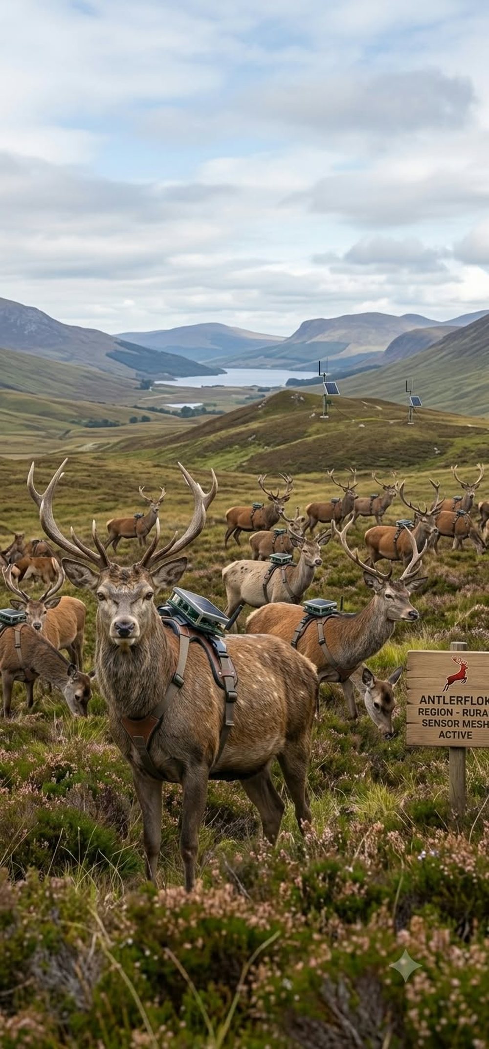
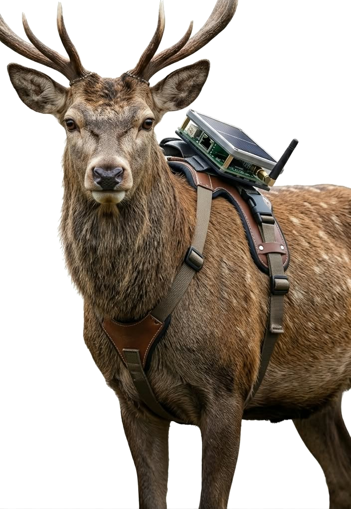
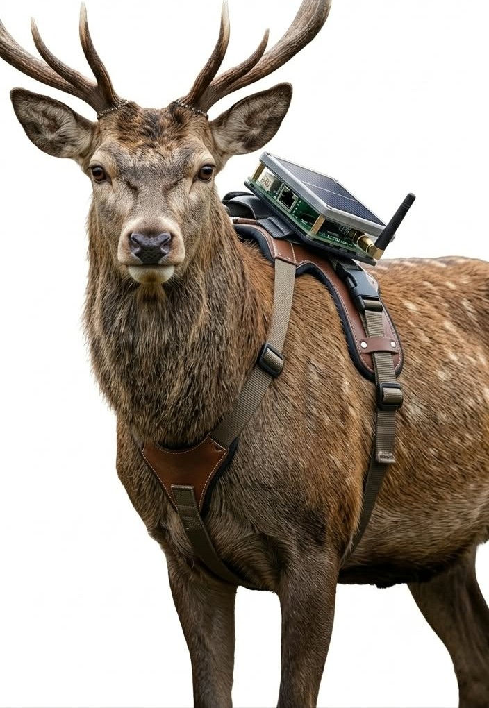
A stag wearing the AntlerFlok solar Meshtastic harness
AntlerFlok · deploying the rural sensor mesh

The herd draws the map.

Elk cross hills nobody knew they crossed. Deer walk the same corridor every dusk. Put the sensor on the animals that already walk the backcountry and the park maps itself. Scroll — he's wearing it.

The Antler harness

Solar. Sealed. Under 1 % of the animal.

A Meshtastic LoRa node on a breakaway harness: GNSS, temperature, humidity, pressure, accelerometer. Logs every minute, beacons every fifteen, charges on its own back. Fitted by the park's biologists under their permits — never by us.

Corridors & crossings

Over a million deer–vehicle collisions a year. The herd knows the crossing.

A season of tracks shows the exact 200 m of highway the herd crosses at 5 AM — where the wildlife crossing, the fence gap or the flashing sign actually goes.

Drones · it's a park

Nodes hung on trees by drone. The whole park pinned in a week.

Sealed solar relays with a hook, flown onto branches along the corridors and ridges — no trench, no pole, no tower permit, no crew on the cliff. Drones also fly the harness checks and the last-heard sweep when someone's overdue.

Ridge cats · bears · lost hikers

A bear on the campground loop is an alert, not a surprise.

Same mesh carries the ranger flock and the free trailhead tags: a mountain lion near a trail closes it before the encounter; a hiker who doesn't come back has a last-heard point before dark.

Fair warning

They might not line up for it like the pigeons do.

The pigeons love to work and, we think (or so we heard), volunteer. Deer are more… peaceful about it. They'll walk off into the trees. That's fine. That's the data.
Solar patch · 1.2 Wcharges on the animal's back
LoRa 915 MHz · Meshtasticclient-mute beacon · store-and-forward
GNSS + climate + motioncorridors, crossings, a fall, a chase
Breakaway harnessfitted by biologists · sheds under load
scroll
AntlerFlok · sister program of PidgeyFlok · by Artificial Mind Hive

Deploying the rural sensor mesh. The herd draws the map.

Where there is no tower there is still a herd, a tree line and a sky. A solar LoRa harness on managed deer, a receiver strapped high on a trunk, and a drone repeater parked over the park give a ranch, a preserve or a national park a $0/month mesh: road-crossing warnings, bear alerts, search-and-rescue text, fire and weather readings, and a map of where the animals actually go.

$18
per harness node, solar, GPS on demand
< 1 %
of body weight on a 150-lb deer
5-10 mi
line-of-sight per canopy or drone hop
$0/mo
915 MHz LoRa, no plan, no tower
A red deer stag wearing a harness with a solar LoRa node and short antenna on its back
AntlerFlok

The herd draws the map.

Where there is no tower there is still a herd, a tree line and a sky. This is the rural sensor mesh, and this is how it gets built.

AntlerFlok
01 · Deer

Deer carry it.

A breakaway harness, a solar node, GPS only when asked. Managed herds first; wild herds with the agency. Every step is a packet, every packet a point on the map.

A tagged herd on open ground
02 · Bears

Bears report in.

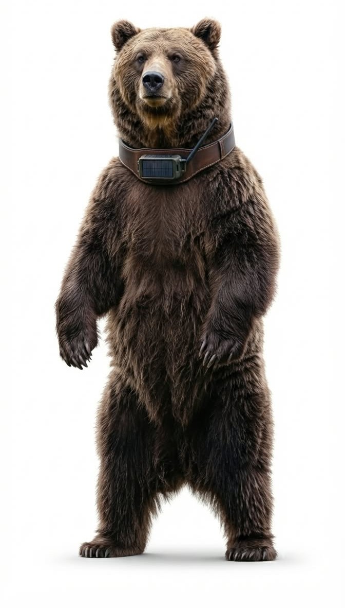
Where an agency already collars bears, the same radio puts them on the mesh. A bear a quarter mile from a campground pings the ranger and every hiker on that trail. Track the bear, not just the human.

A grizzly bear standing upright wearing a collar with a solar LoRa node
03 · Trees

Trees hold the height.

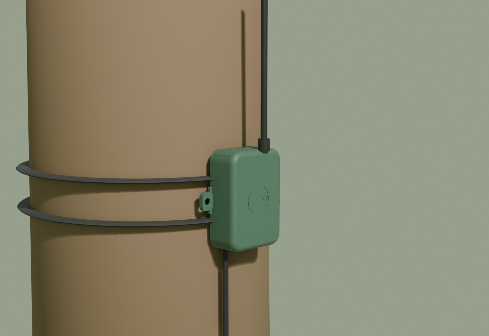
The receiver box on a trunk strap, solar on top, antenna above the crown. Five to ten miles a hop, ridge to ridge, and a weather station on every one for free.

The receiver strapped to a trunk
04 · Sky

Drones fill the gaps.

A repeater at 400 ft when a ranger needs a whole valley: a missing hiker, a fire start, a herd after a storm. Only with the permit, only when asked.

A new region coming online
05 · People

Rangers get the text. Drivers get the warning.

SAR messages with no signal, a roadside beacon lit by the herd, and a season of tracks that tells the agency where the bridge goes. Now the details.

How it works ↓ The studies

The harnessed stag
2,000 nodes per region · $0/month · no towers
How it works

Managed deer, a tree line of receivers, and a drone that parks over the park.

1 · The herd

Managed deer first, wild deer only with the agency

Deer are wildlife: nobody tags a wild deer without the state wildlife agency's permit and a research or management partner. So AntlerFlok starts where the permits are simple: deer farms, fenced preserves, ranches and university herds. Wild herds come with a park, a state Fish & Wildlife biologist, and a study.

2 · The harness

Breakaway harness, solar node, GPS on demand

A quick-release harness (never a fixed collar that can hang up in brush), a solar patch, LoRa radio, motion sensor and temperature. GPS fixes only on schedule or on request, so the node runs for seasons. It drops off on a timer or a command so no animal carries hardware for life.

3 · The receivers

Canopy receivers on trunks, drones on demand

The Petfindr receiver box on a trunk strap, high enough to see over the brush, solar on top, whip antenna above the crown. A drone repeater lifts to 400 ft when a ranger needs to hear a whole valley. One connected roof at the trailhead bridges everything to the map.

The mesh

Ground, tree line, sky: one free network the herd carries for you.

Every node relays for every other. A deer in the creek bottom reaches a deer on the ridge; a receiver on a trunk hears both; a drone parked over the park hears the whole drainage. The animals cover the ground; the trees hold the height; the sky fills the gaps.

1DeerHarness nodes. The moving layer.
2TreesCanopy receivers on trunks. Height for free.
3DronesRepeater at 400 ft when a ranger needs a valley.
4Hikers$15 pocket node: SAR text with no signal.
5RangersTrail counts, fire, weather, bear and poaching alerts.
6The land2,000-point sensing per region; outage-proof.
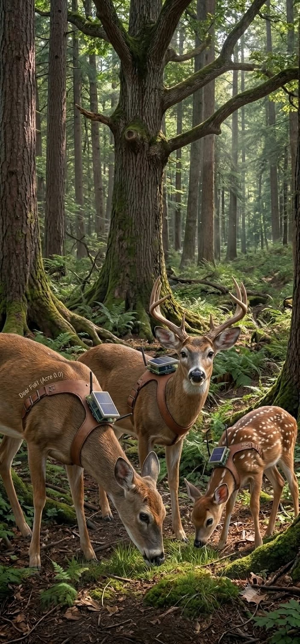
A tagged herd on open ground, nodes on their backs
Acre 0.0: the herd shot. Concept render.
The receiver box strapped to a tree trunk with a whip antenna above it, rendered from the real 3D files
The canopy receiver: the same Petfindr box, two trunk straps, solar on top, whip antenna above the crown. Rendered from the actual STL files (Blender).
The canopy receiver

Strap it high on a trunk and the tree does the tower's job.

  • Where: 20-40 ft up on a ridge-line trunk, above the brush, below the crown. A climber or a pole mount; no drilling, two ratchet straps, comes off in a minute.
  • Power: solar patch on the top face, a small LiPo inside; the box reports its own battery and temperature, so a dying node tells you before it dies.
  • Radio: LoRa router; a whip antenna above the crown gives 5-10 miles line-of-sight to the next ridge. Deer nodes, hiker pocket nodes and drones all relay through it.
  • Sensors for free: temperature, humidity and pressure at canopy height on every ridge: a weather-station network no park has, and the earliest fire-weather signal a ranger can get for the price of a strap.
  • Rules: no nails, no cutting, no metal against bark, off in a minute, and only with the landowner's or the park's written permission. Redwoods and heritage trees get a padded strap and a ranger present.
Drones · because it is a park

A repeater at 400 ft hears a whole valley. It flies only when a ranger asks.

  • What it is: a 30-gram node zip-tied to a consumer drone hovering at the FAA ceiling, or a tethered mast for hours. 20-30 minute flights, on demand: a missing hiker, a fire start, a herd check after a storm.
  • Rules: Part 107 pilot for any paid work; LAANC where airspace requires it; under 400 ft; never over people. National parks ban recreational drones: inside NPS land it flies only under a Special Use Permit with the park, or it does not fly. State parks and private land set their own rules and we follow them.
  • Thermal at night: the same drone with a thermal camera counts the herd, finds a lost person, spots a bear near a campground, and maps burrows for the rodent work in Cat City.
A new region: ridge nodes and a trailhead sign
A new region coming online: ridge nodes, the trailhead sign, the drone beat. Concept render.
Roads & bears · saving the human and the animal

A herd that reports where it crosses the road is the cheapest crossing-warning system ever built.

Warn the driver

Roadside beacon, lit by the herd

A solar sign at the known crossing listens for tagged deer. When the herd is within a few hundred yards at dusk, the sign flashes: "DEER CROSSING NOW". Drivers slow for a live warning in a way they never do for a yellow silhouette. Same box, same radio, a light instead of a map.

Nudge the deer

Buzz, never shock

The harness carries a small vibration motor, the same buzz-before-food cue the Cat City collars use. Paired with a feeding station on the safe side of a crossing structure, deer learn that the buzz means "the good route is this way". No shock, no pain, no fence: a cue and a reward, tested with the biologist on a managed herd first.

Design the safe route

Data for bridges and underpasses

A season of tracks shows exactly where a herd wants to cross, at what hour, in what weather. That is the missing number for wildlife bridges and underpasses, which cut collisions by up to 90 % where they are placed right. We hand the agency the map, and the map pays for the bridge.

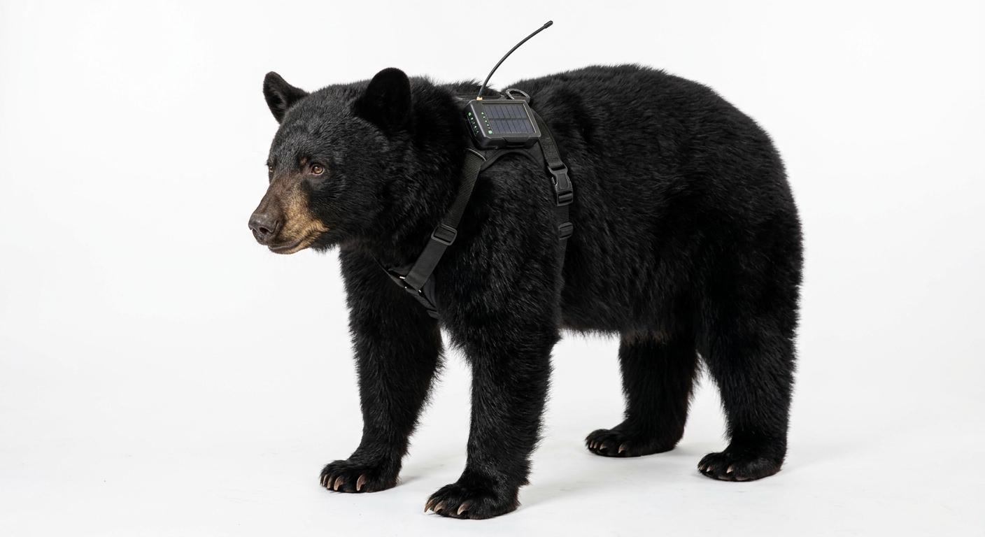
Bears too

Track the bear, not just the human

A black bear with a harness node

Where an agency already collars bears, the same LoRa layer puts them on the mesh: a bear within a quarter mile of a campground, a trail or a school bus stop pings the ranger and every hiker's pocket node on that trail. Bear-proof the trip, not just the trash can. Only with the agency, only on bears it already handles.

Numbers

Deer already cost the country billions a year. A mesh that knows where the herd is costs a park a strap and a box.

State Farm counted about 1.7 million animal-collision claims in the year to June 2025, 1.1 million of them deer, at an average of $5,620 per claim; wildlife-vehicle collisions cost the US roughly $8 billion a year and kill about 200 people. The search-and-rescue numbers, the trail-count numbers and the sourced study are on the studies page.

Read the studies → City studies (Cat City) →

Sources: State Farm animal-collision reports 2024-25; Pew Charitable Trusts, Wildlife-Vehicle Collisions Are a Big and Costly Problem (2021). Our program figures are estimates until a pilot runs.

What deer already cost, per year (US)
Wildlife-vehicle collisions / yr$8B Deer insurance claims / yr1.1M × $5,620 People killed / yr≈ 200 AntlerFlok region program / yr≈ $0.35M (est.) Blue = published national figures. Orange = us, one region, estimate.
Ranches & preserves

Start with your own herd

Fenced deer, elk or cattle: the permits are yours already. We supply harness nodes, two canopy receivers and the map; you get a herd you can see, a fence line that reports, and weather on every ridge.

Parks & agencies

A study, a permit, a pilot

State Fish & Wildlife, a park biologist and a university on the paperwork; we bring the hardware, the canopy line, the crossing beacons and the SAR text layer. Ninety days, one drainage, a report you can publish.

Pigeon side

PidgeyFlok, the city version

Same mesh, same boxes, same map, pigeons on the rooftops instead of deer on the ridges. Cities and parks share one network at the edge of town.

PidgeyFlok →

amh@artificialmindhive.com The scroll story →

A solar mesh node hung by drone on the top of a giant sequoia canopy in Yosemite
Solar top · 2 Wyears of service; the cell is only a buffer
LoRa 915 MHz relay · Meshtastic routerhears every tag and collar on the trails below, passes it tree to tree
Whip antenna above the crownline of sight to the next ridge node and the ranger station
Carabiner hook + straphung by drone in a two-minute flight; no bolts in the tree
Self-reportingbattery, solar yield, uptime, neighbours — a quiet node is a ticket before it's a gap
Weather station for freetemperature, humidity, pressure at the canopy — the park's lapse rate, measured

Pin it to the top of the Grizzly Giant.

A drone hangs a solar relay on the highest branch of a giant sequoia in Mariposa Grove — the best radio tower in Yosemite has been standing for 1,800 years. From there the node hears every tag on the trails below and hands them to the ranger station.

How the tree nodes work →
Concept art: a herd of deer wearing AntlerFlok harnesses in a forest

Acre 0.0.

Every animal a moving weather station and a moving map: temperature by elevation, cold-air pools, the drainage that holds snow, the slope that hits fire weather first. The park gets its microclimates for free.

Read the studies →
Concept art: a tagged red deer herd on open hills with solar ridge nodes behind them and an AntlerFlok 'rural sensor mesh active' sign

Region: rural sensor mesh active.

Ridge nodes on the skyline, harnesses on the herd, a sign at the gate. The valley knows where its animals are, how cold the pass is tonight, and where the crossing goes — for the price of the tags.

Field notes from the herd

The crossing is wherever the herd says it is.A season of tracks beats a decade of guessing where to put the wildlife bridge.
Bears don't file flight plans. Their harness does.Campground-loop approach = same-day text to the ranger + a closure sign before the encounter.
Pin it to a tree. By drone. Done by lunch.Solar relay nodes with a hook, $60–90 each, years of service, one search pays for the whole park's nodes.
"Overdue" becomes a 300-metre circle.Free trailhead tags + tree nodes + a ranger flock overhead. Search starts at a point, not a drainage.
Peaceful, not punctual.The pigeons line up. The deer wander off. Both are working.

Deploying the rural sensor mesh.

Deer, elk, bears and the park's own birds on one open mesh, with the biologists and the permits that make it legal. Managed by us, budgeted by the park, mapped for everyone.

Start a pilot · one trailhead, one corridor, one season

The Antler harness, part by part

Wildlife-collar practice with a mesh radio instead of a satellite bill.

PartJobg
XIAO nRF52840 + Wio-SX1262Brain + LoRa radio, Meshtastic in client-mute6
L76K GNSS + accelerometerPosition when moving; chase, fall, and rest signatures3
BME280Temperature, humidity, pressure at the animal's elevation1
1,000 mAh cell + 1.2 W solarRuns indefinitely in daylight; weeks of reserve40
Sealed shell + breakaway harnessSheds under load; fitted and checked by biologists≈ 100
On the animal≈ 150

Who holds what

The park and its biologists hold the animals, the permits and the collars. We hold the mesh: drone-hung tree nodes, the trailhead boxes, the ranger loft, the dashboard, the battery rounds. The state or park contract pays per trailhead-year. Nothing here is a wildlife study we run on our own — it's infrastructure for the one the park already wants.

Gallery

The Antler harness on a stag The herd, Acre 0.0 Region: rural sensor mesh active AntlerFlok logo